|
| |
|
|
|
Come join us on a virtual tour of Utah's historic
"Canyon of Gold".
|
|
The following has been recreated from our "Canyon
of Gold driving tour brochure, available at most retailers in Piute
County or online at www.atvutah.com
The "Canyon of Gold" Driving Tour and Miners Park were envisioned by
and this article
written by
Bob Leonard.
|
|
The Trailhead
Since the earliest days of human civilization, gold has enticed the
souls of most mortal men.....
|
|
|
 |
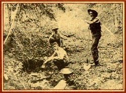
Photo Courtesy Utah State Historic
Society
|
|
Help Preserve our Heritage
DO NOT COLLECT ARTIFACTS
.
|
During the early days
the miners of Bullion Canyon paned their own gold from the creek.
When the placer gold played out, mining operations became expensive
because tunnels had to be dug into the mountain. At this point
many of the independent miners sold their claims to small companies
with capitol and stockholders.
|
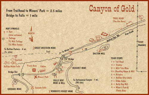
West of Marysvale Utah, the mouth of Utah's "Canyon of Gold" stretches
before you. From at least 1865, flecks of gold in the creek and
veins of gold inside her walls have drawn the hopeful to this canyon
by the thousands.
For the next while (1-2 hours if actually driving the tour), this
brochure will introduce you to the life and times of the miners of Bullion
Canyon. Numbers in this brochure correspond to numbered posts
found along the next 2.5 miles of the road. The road is rough
in spots but is passable by most two-wheel drive vehicles.
At this point set your odometer to "0"
Stop 1 is 0.6 miles past the trailhead.
Next Page [ Stop 1 - The Toll Road ]
|
|
|
|

|
|
|
|
|
|