Utah
Page three
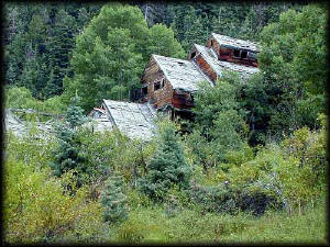
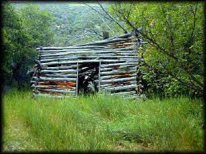 The entire area surrounding Marysvale is full of places like this. You will
come around a corner, and there in the woods will be an old shack. A few
look recently inhabited, perhaps by hunters, but none were really livable.
Quite a few you just wouldn't see unless you were looking for them. The
vast majority were in the areas with a lot of mining activity, such as Bouillon
Canyon. Some were pretty isolated, and if there was a mine around them I
never found it. Besides Bouillon Canyon, there was the remnants of the mining
town Kimberly that I explored. It had little standing, but a lot of foundations
and collapsed wood structures that were being taken over by the forest.
I found one foundation in Kimberly that was huge- a cellar and three fireplaces
remained. I spent some time there, marveling at how grand a structure it
must have been and who the people were that dwelled there.
The entire area surrounding Marysvale is full of places like this. You will
come around a corner, and there in the woods will be an old shack. A few
look recently inhabited, perhaps by hunters, but none were really livable.
Quite a few you just wouldn't see unless you were looking for them. The
vast majority were in the areas with a lot of mining activity, such as Bouillon
Canyon. Some were pretty isolated, and if there was a mine around them I
never found it. Besides Bouillon Canyon, there was the remnants of the mining
town Kimberly that I explored. It had little standing, but a lot of foundations
and collapsed wood structures that were being taken over by the forest.
I found one foundation in Kimberly that was huge- a cellar and three fireplaces
remained. I spent some time there, marveling at how grand a structure it
must have been and who the people were that dwelled there.
This old structure looked nondescript
at first, however it appears to have been a two-story affair of some sort.
I found a lot of rusty iron parts of various sizes in the dirt around it,
none that looked like horseshoes, or anything I recognized. A smithy's building
perhaps? I had a lot of fun exploring these things.
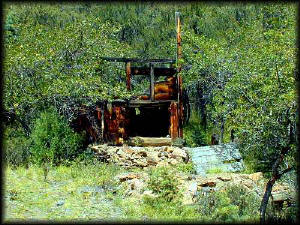
And just so you don't think all of the
buildings that were still standing were small - this monster is in Bouillon
Canyon. It is the remains of an ore mill, and still full of equipment. Bouillon
Canyon was one of the richer canyons near Marysvale, and had a gold rush
of it's own in the late 1800's. There exists now a wonderful collection
of old buildings and interpretive signs throughout the lower reaches of
the canyon called Miners Park, courtesy of the State of Utah. It's more
or less all open, and discretion is advised when exploring such places.
Some of the structures looked pretty unsteady.
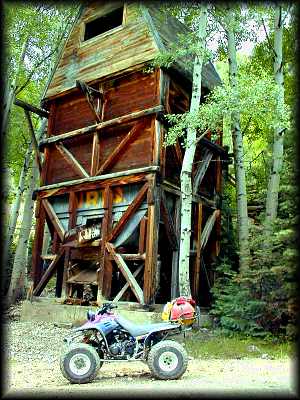
This monolith is a mill of some sort. It was
connected to what may have been a conveyor belt that led to it from a mine
on the hillside above. It seemed pretty solid, and didn't look as old as
some of the other structures behind it. As with most of the things I found,
it looked like the miners just walked away as it had a lot of ore still
in it. I found another mining operation near Kimberly that appeared to have
used a complex aerial tramcar of some sort to carry the ore down the mountainside
to a mill that was not unlike this one.
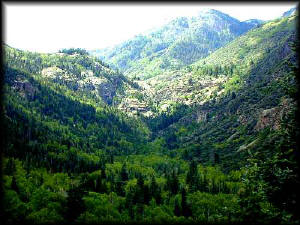
This is a view up Bouillon Canyon from one of
the mines that is about halfway up the hill. You can't see them, but there
must be hundreds of mines in this canyon. Up at the top of the canyon is
the small waterfall pictured below.
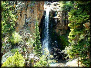
I was able to ride nearly up to this spot in Bouillon Canyon
on my quad. The trail continued on up the hill, and I tried to work my way
around to the top of the waterfall on foot to look down it, but the canyon
got pretty narrow and rough and I never did find a way. The whole area is
full of trails (both vehicle and foot).
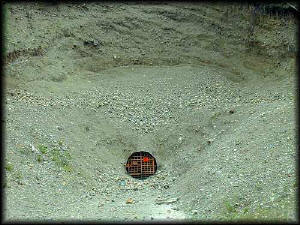
This is a mine that apparently has some potential
left to it. Somebody went to a lot of trouble recently to make sure it can
be accessed, as it appears to have been caving in at the entrance. That
gate is all of eight feet tall!
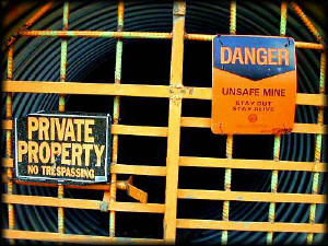
This is the gate into the mine. Unlike most
of the old mines, it was locked securely. Many of the mines had recent mining
claim's tacked up or stored in a visible place. Even some of the ancient
mines had deeds, titles, or claim paperwork dated within the past few years.
I made sure to put everything back as I found it after I looked it over.
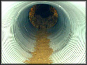
I rested the camera on the gate, set it to maximum
zoom, and took a time exposure of the tunnel. By the naked eye I could only
see about 50 feet of tunnel before it faded off into darkness. In a testament
to the camera, the photograph showed that the tunnel ended (well over 100'
away). You can see where the culvert-pipe ends and the rock-tunnel begins.
I would have been pretty freaked out had there been something back there
looking at me trying to look at it. Alas, although there was the cool moist
breeze smelling slightly sulphurish coming out, there was nothing but dirt.
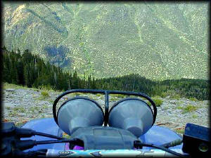
Here is a view looking north down into Bouillon
Canyon. All of the pictures above were taken in the canyon below! I rode
up to the top of the canyon on one of several trails that snake up the edge
of the canyon. The ride up was pretty hairy; a thunderstorm had developed
on the way up. A lightning strike that was very close nearly caused me to
bite off a chunk of the seat with my butt, and I turned around. As with
most storms in the high country, it passed quickly and within the hour I
was able to return. Incredibly, though it stormed almost every afternoon,
I never did get rained on though I rode into many places that had just gotten
drenched. (That dark spot on the left over the headlamp is not smoke, just
a shadow from a cloud overhead after the storm had broken up.)
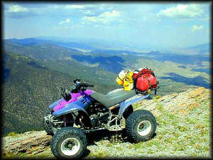
This is from more or less the same spot as the
picture above. The view should have been much clearer, but apparently half
of California was on fire and the smoke from the fires was apparent. A lot
of the folks I met commented on how it usually is much clearer than this.
This view is looking northeast, and with binoculars Richfield and I-70 were
visible directly over the bike. Marysvale is to the right of the photo,
looking down and due east.
Back to page two
Forward to page four
|