|
Utah
Page one
These are a few pics from my ATV adventure in Utah,
August 2001. If you find ATV's or vacation pics grindingly boring,
go somewhere else. There are seven
pa These are a few pics from my ATV adventure in Utah,
August 2001. If you find ATV's or vacation pics grindingly boring,
go somewhere else. There are seven
pages, each with about ten pics apiece, each pic about 40k in size. If you
are using dial-up networking and have the intestinal fortitude to wait it
out, each page should take about a minute to load. If you are riding the
fat data pipe (DSL or equivalent) you have no worries.
After having spent a week at Zion National Park,
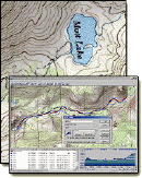
I went to a small town called Marysvale (Location
Map), which is south of I-70 on hwy 89. Marysvale is in a small valley
between two mountain ranges, and has been the locus of a booming mining
industry in the past. The mining industry is essentially gone now (though
I did find active claims, I never did find any commercial mining in progress),
and the town is about all that is left. Utah as a whole is very ATV friendly,
and my plan was to ride some of the Paiute ATV trail system, a 300 mile
trail system that circles through the Fishlake National Forest. It is legal
to take your ATV (Quad, 3-wheeler, whatever) on the paved roads in the towns
adjacent to the trail, and it wasn't uncommon to see more ATV's lined up
in front of the Cafe than autos. Marysvale is right in the heart of the
Paiute ATV trail, which is a 300-mile circular trail put into place by the
State of Utah. It winds through the mountains around Marysvale, up towards
Richfield, and down to Junction. There appears to be an endless amount of
side trails and roads to explore as well, and it's all legal to do so. I'm
a big fan of motorcycles, and I saw quite a few that were trail riding,
but the vast majority of off-roaders were on 4-wheelers. My two ATV's are
Yamaha Warriors, 350 cc single cylinder electric-start 2-wheel drive machines.
I've had them in the desert with paddles, and now into the forest with racks
and knobbies. They seem to go just about everywhere without complaint, and
I've had excellent service from them both.
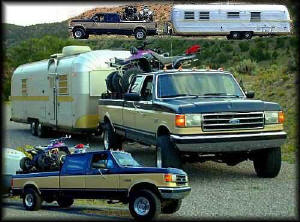
This behemoth is my RV rig. The truck is a 1989 F-350 one-ton crew cab
4x4 powered by a 7.3 liter International diesel engine. The only modifications
are a Banks Turbo on the engine (which makes a BIG difference!), aftermarket
rims with 33" tires, and dual front shocks. The trailer is a 1973 streamline,
which weighs in at 9820 pounds empty, and the Lord only knows how much with
all my stuff in it. The racks on the bed of the truck allow me to store
stuff in the bed (generator, firewood, tools, gas, etc) and still carry
the quads in decent fashion. They have ramps that telescope out and you
literally drive on and off the racks. Made by
Highrider
in Oregon, I'm very pleased with everything except their weight - they add
500 lbs to the truck. Loaded mileage varis between 9.1 and 10.8 mpg.
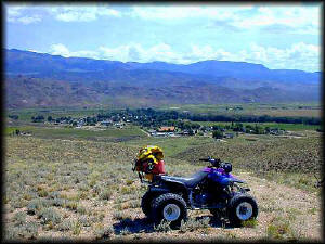
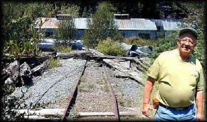
This is Marysvale. A small rural former mining town, now accepting ATV
riders who come to ride the Paiute ATV trail as a source of revenue. Most
folks seemed okay with the ATV's, some were rather indifferent. I stayed
at Liz & Charlie's RV Park (a great place), and was told by the owners that
the main source of the few problems are people that would get out of control
and do something stupid (like riding 50 mph on the main highway instead
of sticking to the side roads of town). I found that I could ride just about
any where near the town without any problems, and once you were in the trail
system proper, you could ride anywhere you pleased. I was told that the
forest service frowned on people trail blazing their own trail, which seemed
ridiculous to want to do anyway because there was so much to see on the
established trails.
The Rainbow Mine
 |
The second day I arrived I rode up a nondescript trail on the West side
of town which ended at an open gate. It had been recently opened, according
to the tracks through it. I went on through hoping I wouldn't incur the
wrath of some property owner, and after five minutes came up on some quads
at the side of the trail near a mine. Several people were nearby, as were
the ATV's they had ridden up on. One promptly challenged me, and I met Mr.
Rollo F. Peterson - the property owner. I braced myself, and explained and
that the gate had been open. Mr. Peterson pretty much shrugged it off, and
we began to talk. I learned he had lived in Utah most of his life, and had
worked in the local mines since the fifties. He related that this particular
mine was in operation as recently as the 70's, and while most mines in the
area made tremendous profits for the miners, this one had had over a million
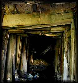
dollars put into it and never showed a profit. I looked inside the entrance,
below, and found it almost completely collapsed around the air ducts and
so forth. Clear water flowed out of what remained of an opening. Mr. Peterson
told me the water coming out of it was normal for most mines, and that most
of the horizontal shafts in the area were put in with a 1-2 degree elevation
so that the water wouldn't pool up.
Mr. Peterson told me a couple of stories of his mining days,
one involving a 50' underground fall into a shaft. Injured, he lay in the
darkness hearing voices of other miners above. Apparently nobody was willing
to risk an immediate descent to his location, until his son-in-law arrived
and immediately descended the shaft and rescued him. He then looked at me
and grinned, "It wasn't that he was braver than anybody else, it was the
fact that my daughter would have killed him if he hadn't come down
to get me!"
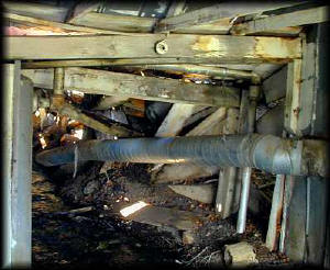
This is the entrance to the Rainbow Mine. The entrance has collapsed
around the air ducts and high-pressure lines that went into the tunnel,
and water ran freely out of what was left of the opening. The entrance was
in a "building" of sorts (see above photo), and to the left of the entrance
were large (six foot tall!) compressors that were used to pump air into
the mine for ventilation and to drive pneumatic equipment.
After talking to Mr. Pederson for some time, I asked if I could
continue further up the trail and explore more of this historic mining area.
He paused, sizing me up, then agreed while cautioning me to lock the gate
after myself on the way out. I thought nothing of it at the time, but I
later found out that he did not let ATV riders onto his property at all
(imagine the liability if somebody falls down a mineshaft). This was evident
since there were no recent tracks on the trails anywhere above the Rainbow
Mine. Some of the roads were all but washed out, especially when they ran
near tailings.
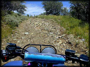
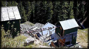
I rode on up the mountain, and found many more mines, mills, and
a lot of equipment. Some of the mines were pretty unsafe looking, some looked
to be in good shape. I found quite a few or mills areas that, except for
the dust and decay, looked as though they were missing only the miners.
There were quite a few "shops" too, that still had equipment and tools laid
out as though the miners had just walked away from whatever they were working
on. I spent the afternoon up there poking around the old buildings, walking
the ore cart rails, and enjoying the solitude. I had lunch at one of the
old mills, just sitting and listening to the wind in the trees as I munched
my sandwich.
"This was truly a great welcome to Utah," I thought.

The view was spectacular.
|