|
| |
|

Fremont Indian State Park or Castle Rock Campground
to Circleville
The ride from Fremont Indian State Park or Castle Rock Campground to Circleville
takes about eight hours. Intermediate times for this portion of the trail
are as follows:
Approximate Section Times
· Castle Rock Campground to Kimberly ------- 2 hrs
· Kimberly to Junction with Marysvale Loop - 0.5 hr
· Marysvale Loop to trail's highest point ------ 1.5 hrs
· Trail's highest point to Utah Highway 153 --- 1 hr
· Highway 153 to Big Flat -------------------------- 0.5 hrs
· Big Flat to Grindstone Flat ----------------------- 1 hr
· Grindstone Flat to Circleville -------------------- 1.5hrs
Starting at the 5,800 foot elevation at Fremont Indian State Park, the
trail follows Mill Creek up to the old mining town of Kimberly at 9,400
feet. It then crosses to the Beaver Creek drainage and the Marysvale Loop
Starting at the 5,800 foot elevation at Fremont Indian State Park, the trail
follows Mill Creek up to the old mining town of Kimberly at 9,400 feet.
It then crosses to the Beaver Creek drainage and the Marysvale Loop at about
8,800 feet. Following Beaver Creek for about six miles the trail rises to
its highest point of 11,500 feet at the pass between Mount Belknap and Delano
Peak. It then descends and crosses the southern end of the Tushars between
9,000 and 10,500 feet before descending Wades Canyon to Circleville at 6,000
feet.
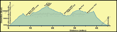
For those starting in Castle Rock Campground, the trail goes north along
the frontage road (Forest Road 478) to the bridge across I-70. Here the
trail joins the one coming from Fremont Indian State Park. For those starting
at Fremont Indian State Park, the route follows Utah Route 4 to Forest Road
113 where it turns south for about a mile to join the route coming from
Castle Rock.
|
| |
 |
|
|
| |
|
|
| |
 |
|
| |
 |
|
| |
 |
|
| |
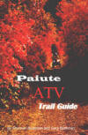
NEW "Paiute
ATV Trail Guide Book". Page
after page of detailed information on the Paiute
ATV Trails. Photos, Maps, GPS Data for every
intersection and point of interest on the trail,
Tip and Tricks for riding the Paiute ATV Trails.
Click Here for More details. |
|
|
|
 |
|
|
|
 |
|
| |
|
|
|
|
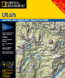
Trails Illustrated topographic maps are designed
to take you into the wilderness and back.
Printed on durable tear-resistant, waterproof
material, this map can go virtually anywhere you
do!
Click here for details. |
|
| |
|
|
|
|
Sponsors
Needed |
|
|
|
Your Ad
Can Go Here! |
|
|
|
Contact Us
Click Here
to request
Details. |
|
|
|
Multiple
Website
Advertising
Special. |
|
|
|
Buy 1 Banner
and |
|
|
|
Get Advertising
on Multiple Websites.
for one low single
ad price. |
|
|
|
| |
|