|
| |
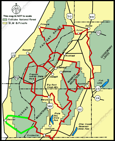
 Beaver Side Trails # 05 or 68w.
The town of Beaver sits on the far south western corner of the Paiute ATV
Trail system on interstate 15 and is the closest trail head for riders coming
from Las Vegas or southern California .The town gets its name from the thousands
of beaver found in the river and mountain streams. Beaver has several designated
ATV routes within the city limits and the city has signed these routes.
Riders are able to access the Paiute ATV Trail by trail 05 northeast of
Beaver roughly following the lower portion of North Creek, then ascends
to the north of Johnson Peak and reaches 9800 feet near Bakers peak before
descending into Lousy creek, crossing Hwy 153 an connects with the trail
01 near Three Creeks lake near where the 01 trail crosses Hwy 153, approximately
18 miles from the city limits. Trail 05 can be challenging for intermediate
riders.
Alternately, trail 68 leaves Beaver to the south and follows South Creek
Road for about 10 miles where it enters the canyon at 7600 feet and climbs
rapidly to over 10,200 feet with several tight switchbacks and narrow ledges
over the next 5 miles and then descends to Anderson Meadow reservoir, where
trail 68 ends at forest road 137. The east end of trail 68 is rated most
difficult. Road 137 is closed to ATV traffic. There are primitive campgrounds
available at the reservoir. The trail becomes 67 and continues north for
2.5 miles where 67 ends at trail 88 near round Flat. You have choice to
follow trail 88 to the north across the flats until you cross East Fork
just before the stream drops into the Beaver River, climb to the Strawberry
Flat and connect with trail 05 at Three Creeks reservoir. This section of
88 is 5.2 miles from trail 67 to trail 05. Your other choice is to follow
trail 88 to the south 4.3 miles past Lebaron Lake and connect with the mail
Paiute Trail 01 at Betenson Flat just at the top of Wades Canyon. The Beaver
side trails are visual feast and rock hounders paradise. To make the loop
from Beaver up 05 and down 68 or vice versa would take about 6 hours and
could be extended to include trails 29 and 27 around Puffer lake which can
easily add 2 more hours to your trip.
continued next page
|
| |
 |
|
|
| |
|
|
| |
 |
|
| |
 |
|
| |
 |
|
| |
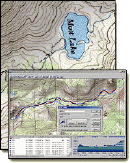
NEW "Paiute
ATV Trail Guide Book". Page
after page of detailed information on the Paiute
ATV Trails. Photos, Maps, GPS Data for every
intersection and point of interest on the trail,
Tip and Tricks for riding the Paiute ATV Trails.
Click Here for More details. |
|
|
|
 |
|
|
|
 |
|
| |
|
|
|
|
Trails Illustrated topographic maps are designed
to take you into the wilderness and back.
Printed on durable tear-resistant, waterproof
material, this map can go virtually anywhere you
do!
Click here for details. |
|
| |
|
|
|
|
Sponsors
Needed |
|
|
|
Your Ad
Can Go Here! |
|
|
|
Contact Us
Click Here
to request
Details. |
|
|
|
Multiple
Website
Advertising
Special. |
|
|
|
Buy 1 Banner
and |
|
|
|
Get Advertising
on Multiple Websites.
for one low single
ad price. |
|
|
|
| |
|