Utah
Page five
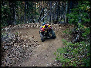
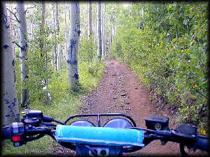
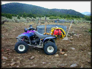
So I'm riding down this particular trail
(right), which has a lot of switchbacks but is mellow at this particular
section, and I get off stretch my legs and snap a photo. As I'm walking
back to the quad, I notice something in the trees to the right, by about
15 feet. "What the hell..?", I wondered, and stood there slightly spooked.
Deciding nobody was around and nothing imminently bad was going to occur,
I checked it out. Removing some moss stuff that was concealing it, I find
that it's a camera! I look it over, and it's hooked to a remote sensor thingy
that has a counter on it. I took pictures of it as it took about 15 pictures
of me.
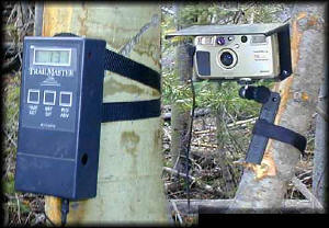
The counter thingy was low to the ground,
with its face away from the trail. A wire ran from it to the camera. But
the counter thingy had no way of knowing I was there... so how was it being
activated? I could hear the camera faintly trigger as it was activated,
but it didn't seem to be in response to anything I did to the camera. It
always activated when I retreated back to the trail near my quad. After
20 minutes of searching, I found the sensor (below).
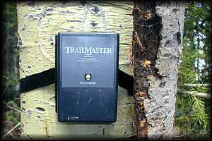
It was hidden by this piece of bark on
the other side of the trail (to the left of the quad in the top photo) by
about 10 feet. It was about 3 times the size of a pack of cigarettes, with
that piece of bark (which I've pulled away) set in front of it which had
a knothole knocked out right over the eye. Needless to say I was pretty
curious about the whole thing, and I spent perhaps a half hour looking for
more cameras nearby without success. I could not even fathom what something
like this would be here for. I was totally flummoxed by what the hell THIS
thing was doing in the middle of the Fishlake National Forest, 20 miles
from any paved road, in an area only accessible by ATV's. Somebody call
Art Bell please. I replaced everything as I had found it, marked the position
with my GPS, and continued on. I wondered what the owner of the set would
think when they saw me taking pictures of their camera taking pictures of
me.
Later that night, when I arrived back at camp, I described the
setup to others. I was told that the volunteer trail group that worked with
the BLM and had been given a federal grant to purchase camera setups so
as to accurately record trail usage which is needed for further funding
considerations. This sounds pretty fair to me, but I was also told that
local group of "activists" ALSO had similar setups, set in places "off trail"
to document people "trail blazing" or riding in areas they shouldn't be
in. They went on to describe the activists using trickery (removing trail
markers and signs, etc) to deceive riders into going "off trail" so they
could document such events.
 I heard several other stories similar in nature, and it was generally agreed
that the "activist group" (which shall remain nameless here since I don't
want them using my site as an example of ATV's wreaking havoc on the forest)
were not welcome in these parts due to such antics. However, their very
presence also means that fewer ATV enthusiasts will do such things
since most everybody loved the Paiute Trail and would never want to jeopardize
it.
I heard several other stories similar in nature, and it was generally agreed
that the "activist group" (which shall remain nameless here since I don't
want them using my site as an example of ATV's wreaking havoc on the forest)
were not welcome in these parts due to such antics. However, their very
presence also means that fewer ATV enthusiasts will do such things
since most everybody loved the Paiute Trail and would never want to jeopardize
it.
I later did some research, and found that the infrared
camera trigger is a
commercially available
unit that is used by hunters and scientists to set off cameras if animals
(or ATV enthusiasts) happen by.
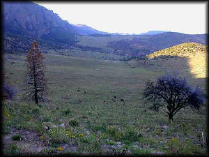
I really enjoyed riding in places like this (above). There
were many of these easy ridin' trails that seemed almost endless. It felt
as though you could go forever on some of them.
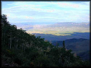
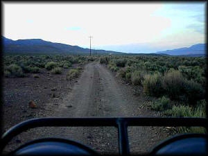
Looking east in the late afternoon. The
view coming down the mountain was spectacular. You can barely make it out,
but there is a small town on the right, Junction, and highway 89 runs north-south
through the valley floor. The main Paiute trail goes through Junction to
the mountains on the other side, but as it was getting late I just wanted
to get back to Marysvale.
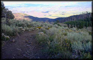
The trail down to the valley floor began
to get nasty. The size of the rocks increased, the trail narrowed, and the
switchbacks became frequent. While scenic, it wasn't what I wanted to deal
with this one afternoon as it was getting late.
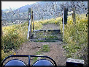
Finally, near to the bottom, the road
smoothed out a lot. This is an ATV-sized cattle guard, of which there are
many since a lot of the land is open to cattle ranching and grazing. Even
though it is State or BLM land, much if it is leased out to ranchers. Note
the Paiute ATV trail sign, which has a particular route or section number
on it that can be used to find where I am on the map.
Finally, thankfully, the trail smoothed
out. It got wider too. And there were quite a few truck tracks on it. Eh..
Who cares. Either way, the road was better. Cow pies, I discovered, are
smoother than rocks the size of basketballs.
It was here, taking a break at this water
tank, I discovered why the road was so much nicer. It was the wrong road.
Great. It's getting dark, I'm in the middle of who-knows-where, some of
the cows have long horns and look generally displeased that a stranger has
invaded their territory, and there are probably mountain lions lurking in
the bushes. The road was going north though, which is the way I wanted
to go, so I stuck it out. It wound down to the gravel Hwy 153 that crosses
these parts from Hwy 89 to the I-15 in Beaver (on the west side of the mountain
range I'd just ridden all day through). I took it the rest of the way down
the mountains into the valley floor, and never saw any cars. I was told
by some of the folks back at camp that this would have earned me a ticket
from the Highway Patrol had they caught me. Luck favors the foolish I suppose.
I finally made it to the valley floor,
and traveled about 15 miles on nameless trails that ran adjacent to Hwy
89 to Marysvale (which, in the picture, is ahead of me by about 10 miles
or so). The Paiute trail actually crosses this valley and climbs the mountains
on the other side of it. It circles around (much like the ride I just did)
and drops back down to Marysvale. My original plan had been to ride this
one part of the "loop", but it took longer than I thought, and at this point
I just wanted to get back to camp, a hot shower, and dinner. This ended
the day I did my longest ride, over 100 miles all told.