www.ATVUtah.com Your Home for ATV Info in Utah

You too can advertise on ATVUtah.com

Home Chat Forums Contents - Search Shopping ATVUtah Merchandise
Previous Page

Create seamless, customized, photo-quality maps...


TOPO! interactive mapping software enables you to create your own seamless, customized topographic maps.
TOPO! screenshot

Easy-to-use tools allow you to draw routes, calculate elevation profiles, add your own notes to the maps, and more.
Click Here For More


"Know Before You Go!"
Off Highway Vehicle Education program.


Help Promote Responsible Land Use Support these Groups
BRC

Blue Ribbon Coalition


TreadLightly!
Tread Lightly!


Utah Shared Access Alliance

USA-ALL is composed of folks who are interested in equal access and recreation on public lands.


The National Off-Highway Vehicle Conservation Council


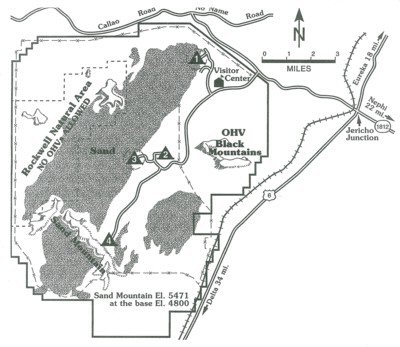
Recreation Opportunities

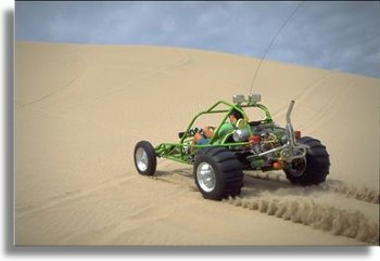
A plentiful sand source and strong prevailing winds have combined to create Little Sahara, one of the largest dunes fields in Utah. Most of the sand at Little Sahara is the result of deposits left by the Sevier River, which once flowed into ancient Lake Bonneville some 15,000 years ago.

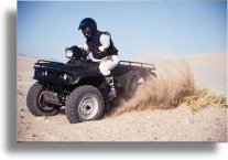
Little Sahara contains 60,000 acres of giant free-moving sand dunes, juniper-covered hills, and sagebrush flats and comprises some of the most heavily used public land in the State of Utah. The terrain is ideally suited for ORV use, as well as for motorcycles, dune buggies, and all-terrain vehicles. Part of the area is managed for ORVs, while the remaining land is preserved for nature study, picnicking, camping, and sand play.

In addition to the visitor center near the entrance, Little Sahara contains four developed camping facilities.

Location: Little Sahara is approximately 115 miles from Salt Lake City, Utah, via Nephi. The entrance road to Little Sahara is 4 miles west of Jericho Junction.

Contact: Bureau of Land Management Fillmore Field Office
35 East 500 North, Fillmore, Utah 84631
Phone number: (435) 743-6811


  Make payments with PayPal - it's fast, free and secure!  
  NEW "Paiute ATV Trail Guide Book".   Page after page of detailed information on the Paiute ATV Trails. Photos, Maps, GPS Data for every intersection and point of interest on the trail, Tip and Tricks for riding the Paiute ATV Trails.
Click Here for More details.
 
  Make payments with PayPal - it's fast, free and secure!  
Trails Illustrated topographic maps are designed to take you into the wilderness and back. Printed on durable tear-resistant, waterproof material, this map can go virtually anywhere you do!
Click here for details.
     
Sponsors
Needed
Your Ad
Can Go Here!
Contact Us
Click Here
to request
Details.
Multiple Website
Advertising
Special.
Buy 1 Banner
and
Get Advertising
on Multiple  Websites.
for one low single
ad price.
 
   
Send mail to our webmaster with questions or comments about this web site.
A Bushman Web Services Creation[
Copyright © 1996 - ATVUTAH.COM ]  [ Privacy Policy ]
Last modified: Wednesday, September 26, 2018